Shortly after the Nisqually quake, Washington State Secretary of Transportation Doug McDonald and then-Seattle Mayor Paul Schell assembled a team of government engineers, private consultants, and citizen representatives to study the problem and proffer a solution. In February of 2002, the Alaskan Way Viaduct and Seawall Project floated several preliminary ideas.
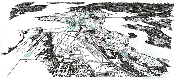
The viaduct proposals--all involve replacing the seawall--include a double-decker elevated roadway similar to the one we have now, only earthquake-proof; a combination elevated highway and "cut-and-cover" tunnel to carry southbound and northbound traffic (or local and through traffic), respectively; and a double-decker cut-and-cover tunnel for all traffic (see sidebar). The routes of the various options would vary slightly, but all three viaduct facelifts feature three lanes in each direction, and include elements such as pedestrian bridges and promenades that would reconnect the waterfront with the rest of the city. The double-decker tunnel could also accommodate a two-track transit system above ground.
"I don't think any of these are the best solution yet," says Tom Madden, the state's engineering manager for the viaduct project, which expects to submit a final recommendation to Transportation Secretary McDonald and Seattle Mayor Greg Nickels this summer. But the cut-and-cover tunnel, which would bury viaduct traffic and its din, open up the waterfront, and potentially expand transit, has emerged as an early favorite.
Of course, the final decision will be one for the voters, and cost is sure to be a factor. The viaduct isn't the region's only transportation priority. Other expensive projects in the transportation pipeline include widening I-405 and upgrading the 520 bridge.
Last week, the State Department of Transportation released the first real estimates for many of these projects, including the viaduct. Depending on the proposal chosen, and taking into account the expense of destruction, excavation, construction, relocating utilities, rerouting drainage, diverting traffic (to ferries, stadiums, local businesses), maintaining the present roadway during the construction process, maybe purchasing more rights of way, and so on, a new Alaskan Way Viaduct would cost somewhere between $3.2 and $11.6 billion. Madden figures it could take as long as 10 years to complete.
That's a long time and a lot of money. The state has earmarked $450 million for the viaduct; a regional transportation package could kick in $2 billion more. It's not nearly enough. So before entertaining any ambitious proposals, it's worth taking a minute to ask one simple question: Does Seattle really need an Alaskan Way Viaduct?
"When we started looking at a replacement," says Madden, "I told the consultants, 'Assume there was no viaduct, ever. Look at where people are and where they want to go, and let's figure out what the ideal transportation solution would look like.'"
In January, project engineers stretched one of those rubber "smart tubes" across the viaduct and started studying traffic patterns. They learned that volume, measured in "vehicle trips" per day, has slipped from its 110,000 pre-earthquake level to 100,000 today. The drop is likely the result of the city's post-quake weight restrictions on commercial traffic and the public's post-quake paranoia about the viaduct's safety. But the viaduct still carries a quarter of all north-south traffic through the city, and 60 percent of that traffic is indeed trying to get through rather than to downtown.
"The viaduct is the lifeline between Ballard and the Duwamish," says Dave Gering, spokesperson for Seattle's Manufacturing and Industrial Council and industry's rep to the viaduct project's citizen-based Leadership Roster. "Those communities are of major significance to the economy of the state."
Home to Seattle's maritime industry, Ballard boasts the country's largest commercial fishing fleet, along with most of the boat repair, supply, and support businesses that service it. In the south end, the industrial Duwamish is the headquarters of Seattle's many marine construction firms, sand and gravel companies, container shippers, metal fabricators, heating oil and garbage haulers, and more. Gering estimates that together both areas employ about 80,000 workers.
"The viaduct is the artery for those communities," says Gering. It doesn't make much sense to send a truck bound from the Port to Ballard inland to I-5, which is already a tangled mess. And mass transit won't help truckers. "You're not going to put your shipping containers on a bus," says Madden. So one important function of the viaduct is to facilitate the movement of freight.
In fact, says Keith Bartholomew, associate director of the University of Utah law school's Wallace Stegner Center for Land Resources and the Environment, the need to move freight "is an argument that's frequently used" to support highway construction or expansion. Bartholomew is also the former director of LUTRAQ ("Making the Land Use, Transportation, and Air Quality Connection"), the legendary grassroots movement that convinced Oregon state legislators in the early 1990s to abandon plans for a new freeway southwest of Portland in favor of developing the existing rail line.
"If we really are serious about moving freight, then let's go ahead and invest in road capacity, but let's make it an investment for freight only," says Bartholomew. "We have bus-only lanes and carpool-only lanes. Let's build a facility that's only for trucks." Otherwise, he argues, "you can build capacity, but it's been proven over and over again that that capacity gets soaked up by people driving cars for discretionary trips."
Bartholomew's claim is supported by research from the Surface Transportation Policy Project (STPP), a Washington, D.C.-based nonprofit that studies transportation issues at federal, state, and local levels. A recent STPP study of traffic congestion in 60 U.S. cities found that expanding highways in metropolitan areas doesn't ease congestion, even when road-building outpaces population growth. In fact, delays got worse in the metropolitan areas that built the most roads, "in part," says the report, "because adding capacity to highways actually generates additional travel, as people take additional car trips and new development creates even more demand."
Cars greatly outnumber trucks on the viaduct. Based on traffic data collected by viaduct project engineers, the highway handles about 95,000 non-commercial vehicle trips a day. Forty percent have a downtown destination; beyond that, traffic engineers don't really know much about the nature of the car traffic. How many trips, for instance, involve cars with a single driver? How many of those drivers are commuting to work, shopping downtown, running errands, shuttling kids? How many of those drivers would abandon their cars for rapid transit if it were available? In other words, how much car traffic does the viaduct really have to accommodate?
No one can answer that question until project engineers provide a more detailed analysis of usage patterns. Grace Crunican, Seattle's new director of transportation, is withholding judgment on the viaduct until she can study that data. But one thing is clear, says Crunican, fresh from a five-year stint as director of Oregon's Department of Transportation, "You need parallel transportation systems. You need alternatives so that everyone isn't funneled into [the same place]."
So, if we proceed on the assumption that Seattle does need some version of the viaduct, some north-south alternative to I-5, then what kind of transportation system should it be?
San Francisco's Embarcadero Freeway is often mentioned as an apt comparison to the Alaskan Way Viaduct: two elevated waterfront highways damaged by earthquakes.
At 5:09 p.m. on October 17, 1989, as baseball fans poured into Candlestick Park for Game Three of the World Series between Oakland and San Francisco, a 7.1 magnitude earthquake struck northern California. The epicenter was in the remote Santa Cruz Mountains. But 50 miles north, in the cities of Oakland and San Francisco, the earthquake caused 63 deaths and some $6 billion in property damage.
The 1989 Loma Prieta quake remains the largest quake along the San Andreas Fault since the great San Francisco earthquake of April 1906. It severely crippled San Francisco's highway system. The most lethal damage occurred on Interstate 880, when that highway's upper deck collapsed onto its lower roadway, killing 41 people. San Francisco's Embarcadero Freeway remained standing, largely because its weak joints had been retrofitted with external cables in the early 1980s. But the freeway was closed immediately after the earthquake. It never reopened.
Two years before the Loma Prieta earthquake, San Franciscans swayed by dire predictions of gridlock voted, by a slim margin, to keep the Embarcadero Freeway open. In the days following the 1989 temblor that damaged or destroyed most major commuter routes in the Bay Area, San Francisco's traffic was a hopeless snarl. But commuters adjusted. They had to. Former drivers started taking the ferry, they took BART, they carpooled, they found other ways to get where they needed to go. Many stuck with their alternative even after the bridges and roadways reopened. "People didn't go back to their cars," says Boris Dramov, an urban designer with San Francisco's ROMA Design Group, who has worked on both the Embarcadero and recent Alaskan Way Viaduct Project plans. "There was a transfer of trips to transit." The dreaded gridlock didn't materialize.
If San Francisco survived without the Embarcadero, can't Seattle get along without the viaduct?
Not quite. There are some important differences between the two roadways. For one thing, the Embarcadero handled 30,000 fewer vehicle trips a day, and was never as central to San Francisco's traffic flow as the viaduct is to Seattle's. The Embarcadero Freeway was supposed to stretch from the Bay Bridge to the Golden Gate Bridge, but it never made it past Broadway. "It wasn't ever completed so it was never a fully effective state route," says Dramov. "It acted like an extended on/off ramp." Nevertheless, there is one important lesson Seattle can learn from the Embarcadero's demise, and in fact from most instances where an urban highway is closed.
When asked whether the same transfer-to-transit trend that post-Embarcadero San Francisco witnessed might also happen in a viaduct-less Seattle, Grace Crunican is skeptical. She cautions that she is not up to speed yet on the viaduct project. Still, says Crunican, "I've driven it and watched how it functions. It is, in part, a reliever to I-5, which you want to have in a downtown area like this. It connects West Seattle. It plays an important role in city-to-city trips. I'm hesitant to just say we can subtract it out. On the other hand, I'm hesitant to not put that on the table before we move on."
Despite his progressive credentials, Peter Hurley is also reluctant to advocate tearing the viaduct down. But as executive director of Seattle Transportation Choices Coalition and the citizens' environmental voice on the viaduct project, Hurley does want to see something more innovative come out of the viaduct discussions. Hurley's Transportation Choices Coalition has a three-part mantra that he's been chanting to members of the viaduct project, and more recently to Crunican. One: Prevent car trips and thus traffic by designing communities where it's easy to walk or bike or take a bus or train. (This was the approach taken by members of Oregon's LUTRAQ project, who showed that a new freeway wasn't as desirable or cost-effective as finishing the rail line and developing communities around the stops.) Two: Give people lots of transportation choices. Three: Make "strategic" investments in roads. In other words, says Hurley, "Build roads to move people and freight, not cars."
Moving people, not cars, is an intriguing twist on transit, and one that, according to Barbara McCann, is often overlooked. McCann is a director at Washington, D.C.'s Surface Transportation Policy Project. "The question [transportation project managers typically ask] is, 'How can we move the cars?'" she says. "If you ask, 'How can we move the people?' you might come up with a different answer. The important thing is not necessarily providing for the current situation." Especially since, in this case, viaduct project engineers aren't clear on all the details of the current situation--that is, where all the people who drive the viaduct are going and why.
It may be that following San Francisco's lead--tearing down the viaduct and rerouting traffic--is impractical in Seattle. Tom Madden says that the viaduct project team did entertain an Embarcadero-like solution early on. They abandoned it, says Madden, "because we still need something to carry that 60 percent of the people who aren't trying to get to and from downtown."
But why should Seattle have to worry about, let alone pay for, a road system just so that some suburbanite can blast right by the city on his way from Everett to IKEA? As anyone who has driven to Vancouver, B.C. knows, there are no highways that speed drivers through the middle of that city. New York punishes drivers with bridge and tunnel tolls while offering speedier alternatives. New Yorkers who commute from Long Island to Manhattan can tell you that the train and the subway are infinitely faster than the car. Why should Seattle not only invite but also subsidize more congestion when most other major cities actively discourage automobile use?
Crunican finds this isolationist attitude puzzling. "There's this funny thing about the citizens of Seattle," she says. "They feel more connected to the international community than to the surrounding towns inside King County. They're part of the world, but they're not particularly a part of King County. And we are a part of King County. We need to own the fabric of the region, which is life and its business. We can't be separated by posting a sign at the city limits that says, 'If you're not coming to Seattle, please take I-405.'"
Crunican believes in balance. She points to Detroit, Atlanta, Houston, and Phoenix as cities at the pro-auto end of the spectrum. "They said, 'We're going to build you another road, we're going to build you another road, we're going to build you an outer, outer loop--there isn't a road we don't like.' Well, you can't get around any better in those cities. The quality of life isn't up. There's a balance between giving a go signal to the car and going the isolationist route by saying if you're in a single-occupant car you can't come into our city. There's got to be a balance."
This brings us back to the original question: What kind of transportation system should replace, or displace, the viaduct? All current proposals call for six-lane roadways, three lanes in each direction. Do we really need six lanes?
First of all, a three-lane highway becomes a four-lane highway for stretches once engineers add on- and off-ramp auxiliary lanes. And each lane costs a bundle, a bigger bundle if it requires the purchase of an additional right of way on either side of the existing footprint, which it almost certainly will. The Battery Street Tunnel is a squeeze now, and new buildings north of the Market are snuggled right up against the viaduct ramps. "There is no extra room," says Madden.
Secondly, if San Francisco's experience teaches us anything, it's that some, if not many, viaduct drivers, forced out of their cars by circumstances (like a closed or clogged roadway), will stay out by design if given transit alternatives that are cheap, convenient, reliable, and, most of all, fast.
Third, there are long-term benefits in weaning people off cars, benefits to the environment, the public health, and the individual pocketbook. According to an STPP study of transportation costs in 28 metropolitan areas, Seattle households spend more on transportation (17.1 percent of the family budget) than on food, utilities, or healthcare, more in fact than on any other line item except housing.
The viaduct project team isn't really ignoring mass transit. Metro buses are part of all the current proposals. The cut-and-cover tunnel option includes a "potential new two-track transit way." The monorail's proposed Green Line could run nearby, following Fifth and Second Avenues. According to Robert Spillar, supervising transportation engineer with Seattle-based Parsons Brinckerhoff, a consulting firm working on the viaduct project, "There is the potential for monorail in the corridor, and there's the streetcar that could extend to Seattle Center or Lake Union." But Spillar's comments notwithstanding, there isn't any real plan for siphoning volume off the viaduct and onto mass transit.
What such a plan would look like is up to the experts. But it's safe to say that if the city wants to get people out of cars, it has to put the "rapid" back in rapid transit. That means that buses, even express buses in HOV lanes, aren't the answer. They're just too slow. Seattle needs to get transit off the streets and run it either above (monorail), below (subway), or beside (light rail).
Imagine a tunnel with two lanes in either direction for all through traffic. One lane is trucks and buses only, and to ease congestion, freight haulers get incentives to move their cargo at night or at off-peak times, which many already do. The other tunnel lane is for cars travelling through the city. Vehicles headed downtown get routed along a redesigned Alaskan Way. If Alaskan Way gets clogged, well, all the more reason to leave your car at home, or at least at the downtown limits, and ride the bus, trolley, or monorail. It's gridlock as motivator, the stick to rapid-transit's carrot.
Mass-transit has always been a tough sell in Seattle. This is odd for a city that sees itself as progressive and environmentally conscious. It's understandable, however, given the fact that regional transit projects have a well-earned reputation for mismanagement and cost overruns, and given that to date mass-transit solutions haven't embraced the concept of speed. New Yorkers don't take the subway because it smells good; they take it because it's fast.
STPP's Barbara McCann says that resistance to mass transit is also historic: "Most of the [public's] transportation dollar have been programmed for roads, so decision-makers are used to having this single product line. For many years in the United States road-building has been associated with economic development. Cars and roads are associated with freedom."
Sitting in traffic isn't very freeing. Neither is the sight of narrow city streets stuffed with hulking SUVs. "You do get to a point of diminishing returns," says McCann. "Seattle is there." But Seattle doesn't have to stay there, provided its citizens will climb out of their cars and its officials will give them fast and efficient transit to climb into.
Building new roads and expanding old ones won't relieve congestion. Studies have shown that time and time again. There are plenty of modest and cheap ideas that help chip away at the traffic problem. The 45th Street Merchants Association used a $5,000 city grant to convince neighborhood folks that they could take care of most of their business and shopping duties along the 45th Street bus line. On a larger scale, we need to think, well, big: Maintain the roads we have, replace the viaduct with a smarter, quieter tunnel system that reclaims the waterfront, and add a monorail or some kind of truly speedy transit alternative in that corridor.
None of this will come cheap. Nothing of value ever does. Boston's Big Dig, a far more colossal effort to replace an elevated downtown artery with an eight-mile-long, eight-lane-wide underground expressway, is at $14 billion and counting. But the cost and the scope of the project shouldn't be deterrents. The prospect of a safe, efficient viaduct, a quakeproof seawall, a new and improved waterfront, and rapid transit to boot is exciting. Seattle has tackled major projects before--upgrading the Port, for one. The city's 21st-century transportation solution won't get realized overnight. It doesn't have to. It's a long-term vision whose complexity, ambition, and yes, even its new, multibillion-dollar price tag should shape, but not stall, the viaduct/seawall rehab.
Grace Crunican isn't ready to get behind any particular viaduct solution until all the data are in. But she believes it's inevitable that the city will create a better transportation system. "It's our generation's responsibility to put something in place," says Crunican. "The time for these questions is now."
A literal act of God has given Seattle a chance to rethink transportation. In a way, it's a shame the viaduct survived the Nisqually quake. If Seattle, like San Francisco, had been forced to shut the roadway down cold turkey, the city would probably know what it needed by now, and be on its way to building it. Instead, the city and state await a decision from the inclusive team they recruited to tackle the problem of the shaky roadway and even shakier seawall. The team's recommendation will have to pass muster with the public that's paying for it before any rebuild or retrofit project gets off the drawing board.
Some people think it's too late for radical changes to Seattle's transportation policy--changes like containing the size of the viaduct while adding a major transit component to the project as a way to both force and entice Seattleites out of their cars. "If we had thought more clearly in the 1970s, that would have been the time to invest in other systems, but that horse is out of the barn," says Bruce Agnew, director of the Seattle think tank Cascadia Discovery Institute and a citizen rep on the viaduct project. Besides, adds Tom Madden, when it comes to actually getting out of their cars, "people just aren't going to do it."
There's a chance Madden and Agnew are right. But Seattle shouldn't let that possibility limit the options or crimp the vision, not yet anyway. Besides, others respectfully disagree. And so, it appears, does Grace Crunican, the new kid in town.
"They say you can lead a horse to water, but you can't make him drink," says Crunican. "I think the citizens of Seattle understand the connections between work and life and the environment. I think they want to do something different. If you keep things tight on the road side and push hard on the transit side, I think it's possible. I think in Seattle they'll actually drink."